

The Stories They’ll Tell
It's said that memories are some of the few things in this life that can't be taken away. With most East Kootenay glacial ice destined to disappear by the end of the century, these are some of the tales that will be left behind.
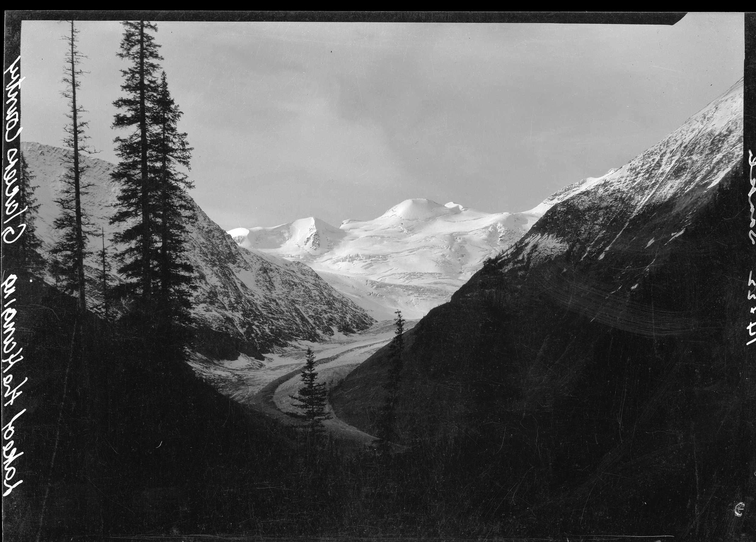
Hang ‘Em High — Shot in the 1920s, the Lake of the Hanging Glacier and Horsethief Creek Valley, as seen through the pioneer lens of Byron Harmon, a Washington State-born photographer who was amongst the first prolific visual chroniclers of the Canadian Rockies. The glacier is located west of Invermere and Radium in the Purcell Range.
LAKE OF THE HANGING GLACIER
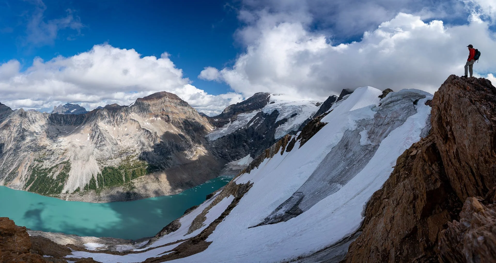
Green Dream — Hiker Graeme Lee Rowlands surveys Lake of the Hanging Glacier and its once abundant ice. The remarkable location was featured in a 1919 issue of National Geographic entitled "On The Trail of a Horse Thief," back when the glacier cliff face loomed as much as 100 feet above the waterr — Pat Morrow Photo
Long before social media, Byron Harmon’s camera talents and physical stamina made him the star photographer of the Rockies and neighbouring mountain ranges.
On one early 1920s expedition, Harmon traveled with mountain guide Conrad Kain, Tom the camp boy, and two U.S. clients. Cora Johnstone Best was a medical doctor and Audrey Forfar Shippam was an artist who worked in sculpture, printmaking, and painting. Both women were skilled climbers and members of the Alpine Club of Canada.
In her highly entertaining report in the 1923 issue of the Canadian Alpine Journal — accompanied by Shippam’s photographs — Johnstone Best described their adventures exploring 300-metre-long glacier ice caves, replete with miserable rain and snowstorms, and the antics of an uncooperative pack horse named Old Bill. The two women rode their horses and scrambled peaks on their own. One day with Kain, they made a first ascent of a 3,353-metre peak they named Conforjohn.
Describing Lake of the Hanging Glacier, Johnstone Best wrote, “Such a scene of wild grandeur; such cold majestic beauty; peak after peak glittering in the afternoon sun, eight great hanging glaciers in a semi-circle; the lake, itself a blue gem in a setting of beaten silver, juggled odd shaped icebergs that turned and twisted in constant movement, offering a kaleidoscopic array of prismatic colours from the palest mauve shade to deepest marine blue.”
She went on to share some behind-the-scenes anecdotes about the team’s mission to purposefully set off an avalanche that Harmon could capture in a dramatic photo.
“There hadn’t been much said about it, but those thirty-six sticks of dynamite had been carried all the way from Windermere on one of the horses (not Old Bill) to assist Nature in the final act of bringing forth a natural phenomenon.”
Harmon and Shippam installed their moving picture and still cameras at precise locations, while Kain dug a hole in glacier ice and lit the fuse: 17 sticks in all.
“Harmon took a last anxious look into the finder — yes, the exact peak, and it was rounded high with new snow. He mopped his face and looked along the line to see if everything was ready. It was. This would be a grand success, undoubtedly. The earth shook; the air turned purple; Mother Earth agonized, and a few pounds of ice tinkled off into the water as the smoke drifted away.”
They waited hopefully for a larger avalanche to happen. Meanwhile, everyone had forgotten about Old Bill.
“When the first report of the discharge took place, Old Bill started a little charge of his own. He came down the stretch hitting on all four, his mane flying, his nostrils dilated and flaming, his eyes holding the fire of battle. He hit Harmon first! Down went the camera and Old Bill walked up the spine of the vanquished photographer, hit the second, third and fourth cameras with sickening precision and careered off down the valley. And then it happened! The whole top of the mountain eased off a bit, toppled and crashed to the glacier below in the mightiest of the mighty of avalanches.”
Harmon and Shippam moved their cameras over to the “big glacier” where they captured excellent, and now historic, photos.
STANLEY GLACIER
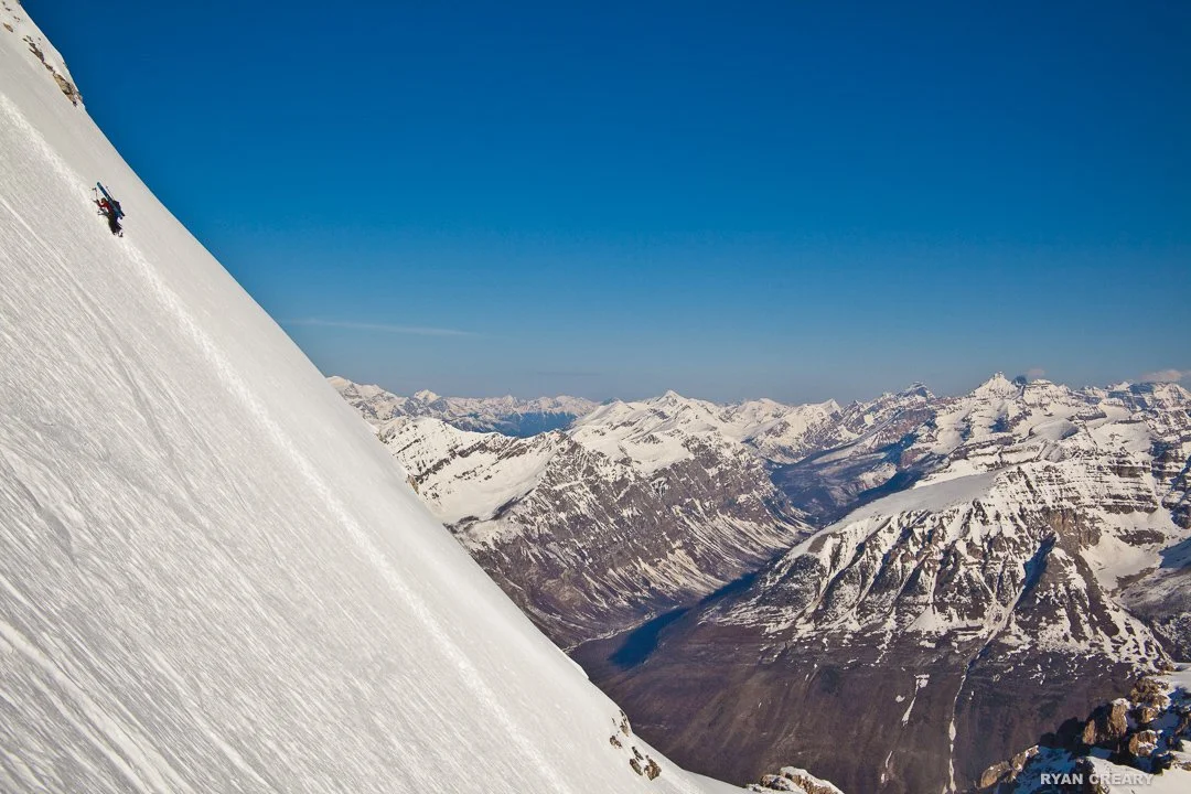
Bootscooter — Amidst a springtime sea of Rockies peaks, ski mountaineer Christina Brodribb makes an early morning ascent up Mount Stanley’s north face. — Ryan Creary Photo
Jutting into the clouds above Highway 93 South in Kootenay National Park, Stanley Peak is an attention grabber of the first order.
At 3,155 metres, it’s not among the Rockies’ highest peaks, but its steep North Glacier and massive limestone headwall looming so close to the road make it unmissable.
The short hike to its base likely influenced prominent U.K. mountaineer Edward Whymper to make its first ascent via the northwest ridge in 1901, with his guides J. Bossoney, C. Kaufmann, C. Klucker and J. Pollinger. By then, an aging mountaineer haunted by ghosts of partners who died during his first ascent of Switzerland’s Matterhorn, his celebrity trip was financed by the Canadian Pacific Railway Company. Whymper named the mountain for Fredrick Arthur Stanley, Canada’s sixth Governor General, better known nowadays as the namesake of hockey’s top trophy.
The North Glacier was first climbed in July 1966 by alpine master Heinz Kahl with Nick Ellens, since known as the Kahl Route. Writing in the 1967 issue of the Canadian Alpine Journal (CAJ), Ellens pronounced, “Heinz said he considers that on Stanley Peak (10,351 feet), the east face has the longest continuous snow-ice face in the Canadian Rockies, with the exception of Mt. Robson.”
Their ascent up a steep slope that Kahl estimated to be 65 degrees included him falling into a crevasse where he became “wedged a few feet below the surface so that no pull came on the rope. He quickly scrambled out, however, cold but uninjured.”
Two years later, Eckhard Grassman and Urs Kallen — the latter of whom is still climbing in his 80s — made the first winter ascent up the North Glacier. Reaching the top required them to tunnel through a cornice, which they managed safely, but later they saw that an avalanche had erased 300 metres of their ascent route.
What goes up, though, must come down — and Stanley’s North Glacier has become a superstar in the roster of steep ski lines. Its first descent is credited to Canadian Rockies steep skiing visionary Doug Ward in the 1980s — a time when super-steep ski lines weren’t yet popular. The line, he said, was irresistible.
“It was likely a line I had first seen from the road, and the aesthetics of a line are the strongest draw for me,” Ward says. “Stanley's north face has that in spades.”
“I’d not heard any rumours of other descents, even by my second descent in ’87,” he adds. “There was nowhere near the pressures for these lines back then; not many folks aspiring to the classic ice-climbing routes.”
While the glacier is certainly not as full as it was in the 1980s, it’s lost none of its allure, declares well-known Rockies hardman Jon Walsh.
“Stanley has to be one of the most classic steep-ski descents in the range,” he says with enthusiasm.
For those who don’t plan to ski or climb the glacier, nor the ice and rock routes on the headwall cliffs, Parks Canada offers fascinating guided tours of Burgess Shale fossil beds in the rubble at Stanley’s base.
DIBBLE GLACIER
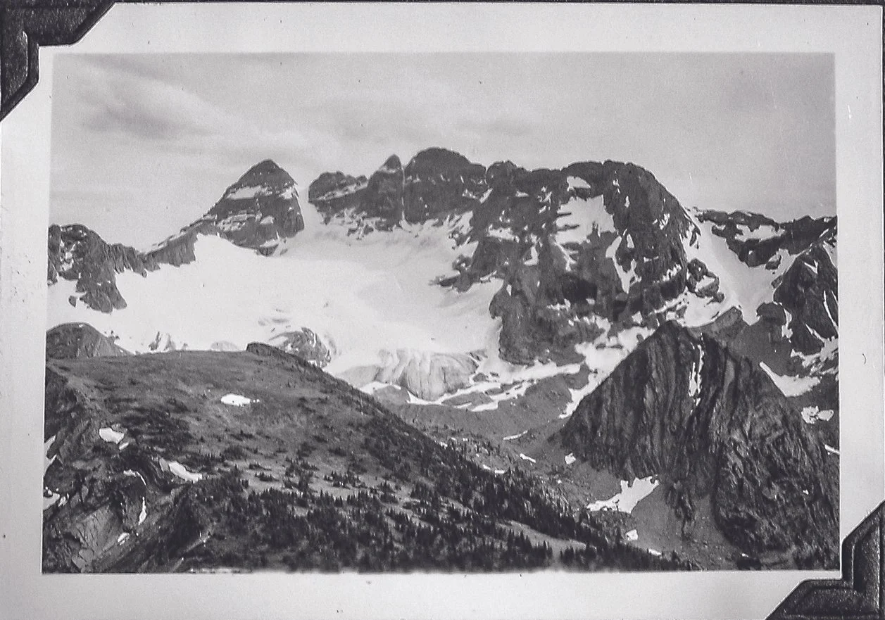
Hey Dibble Dibble — Photographed in 1938 by Frank Morro, Dibble Glacier sits on the northeast side of The Steeples, the famous group of peaks overlooking Cranbrook east of the city.
While The Steeples tower above Cranbrook, tucked behind them is a small, northeast-facing glacier named Dibble that can’t be seen from the road. Located in the Hughes Range — a sub-range of the Kootenay Ranges in the Southern Canadian Rockies — it’s a favourite glacier for locals to visit, and one that makes its appearance for climbers on Mount Hungary or The Steeples, and for hikers exploring the area’s higher ridges.
Growing up in Jaffray, Randy Boardman remembers his father taking him into the area where he often hunted. Now, some 30 years later, Boardman recalls seeing Dibble Glacier for the first time as a teenager.
“I looked at it and thought, 'Hey, there’s a glacier back here. We could ski on that!'” he says. “So, we did. We didn’t have touring gear, we used Securefixes on our downhill skis — those would have been 215s, GS skis. But we were 18, so we’d eat a peanut butter sandwich, head to the mountains, and be gone for three days.”
While the more popular destination for off-piste skiing was in the nearby Island Lake Lodge area, Dibble offered more of a challenge to those who took it on.
“We skied on The Steeples because we were starting to look for something bigger.”
Dibble Glacier continues to draw skiers looking for a good line, in particular Dibble Couloir, often described as the most prominent line in the Fernie area, visible from many surrounding ridgetops.
Kimberley resident Pat Bates first visited Dibble as a young boy more than 50 years ago with his uncle.
“My uncle, who has now passed on, was a guide outfitter who had a cattle ranch right beneath The Steeples,” Bates explains. “My family also had a summer home on the same property. So, my first visits to the Dibble Glacier area were as a young boy with him on horseback during the summer. I soon learned that I could visit much more terrain with less hassle on foot, and so it began.”
Since then, Bates has visited Dibble regularly — including a couple of trips where he climbed the glacier to descend The Steeples “chossy” west side.
“The climb up is straightforward glacier travel, the last bit quite steep,” he describes. “The problem nowadays is that the loss of ice thickness is exposing large amounts of loose rock on both sides near the top, very similar to the Bugaboo and Snowpatch Col situation.”
Living close by though, he appreciates still having easy access to the area.
“The area has a special place in my heart, having had the opportunities that I had growing up,” Bates adds. “As a youngster, I had no idea that there might actually be bigger and equally spectacular mountains anywhere else in Canada.” Later, though, the same uncle took Bates on his first visits to the staggering mountains of the Rockies’ national parks.
“All my trips to Dibble are memorable, winter or summer, for many reasons,” Bates says. “Some of those are because of time I spent in the area with both close friends and relatives who are no longer with us.”
BUGABOO GLACIER
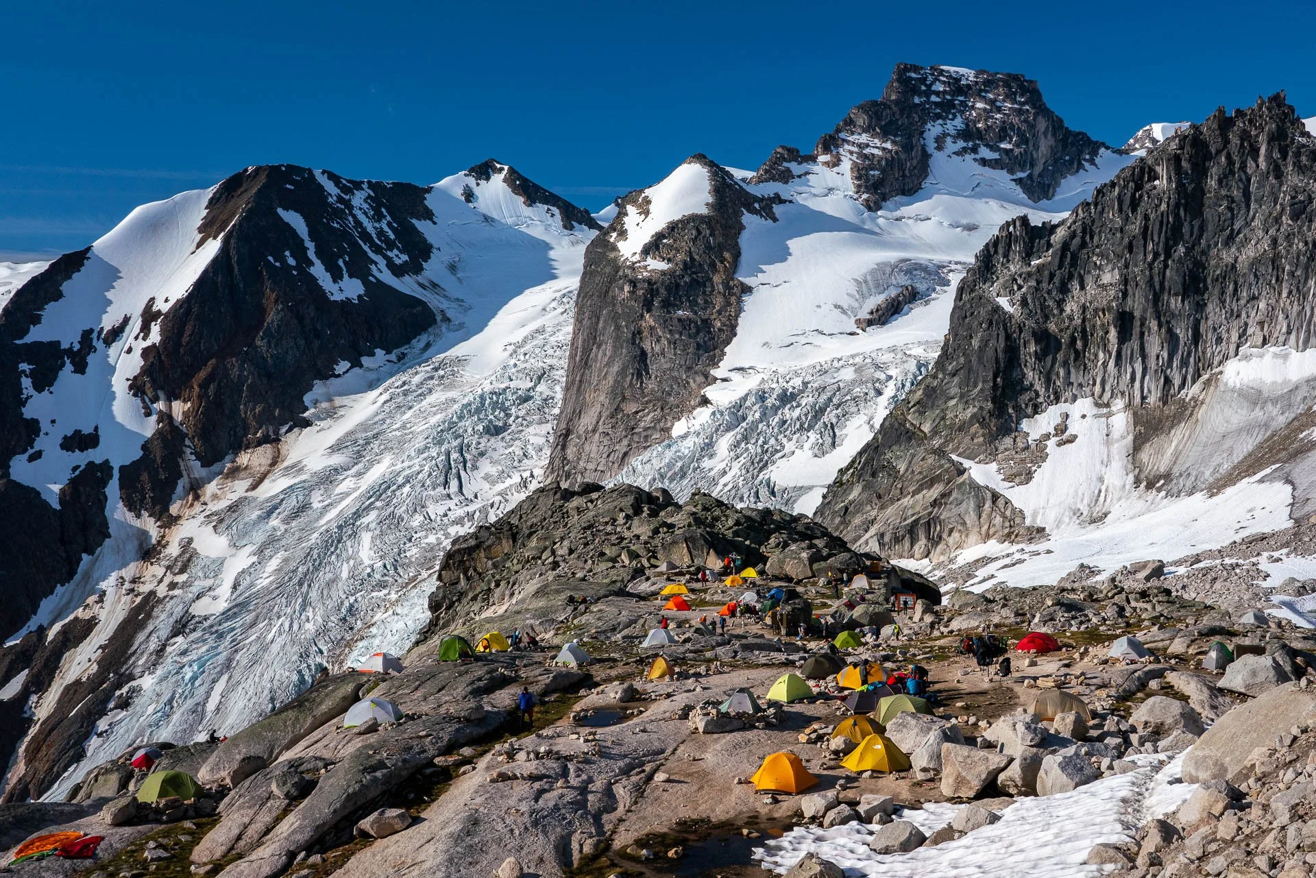
By boot, belay, and bird — The same snow and towering rock that lured heli-skiing pioneer Hans Gmoser to Bugaboo Glacier in 1965 now attracts thousands of hikers and climbers to ‘The Bugs’ basecamp locations like Applebee Campground. — Pat Morrow Photo
Driving the final potholed kilometre of the logging road toward its dead end at a parking lot often crammed with plates from dozens of states and provinces, the road suddenly curves, the forest opening up to an expansive view ahead.
“Holy s**t,” one might say at this point. Whether viewed by a neophyte or seasoned orophile, the sight of the stately granite Houndstooth Spire emerging from Bugaboo Glacier inevitably elicits expletives.
The first non-Indigenous visitors were miners. The term Bugaboo, meaning an imaginary object that provokes fear, first appeared on the 1893 Gold Commissioner’s map. The legendary Austrian alpine guide Conrad Kain — who later settled near Invermere in Wilmer — first passed through the area in 1910 on a surveying mission with Alpine Club of Canada co-founder A.O. Wheeler and photographer Byron Harmon, and he was immediately smitten.
Kain returned to the area in 1916, making numerous first ascents in the Purcell Mountains before arriving at Bugaboo Glacier. After establishing a high camp, three days later Kain led his most impressive first ascent — then among the world’s most difficult — the Bugaboo Spire via the south ridge, with clients Albert and Bess MacCarthy, Henry Frind, and John Vincent.
In many trip reports over the decades, the gravel forestry road approaching the peaks is frequently mentioned. Spencer Austin wrote in the 1938 Canadian Alpine Journal, “It is definitely not advisable to attempt the road with a passenger car.” But he added, “Even the most blasé climber, I imagine, would be impressed by his first sight of the spray of spires rising out of this glacier.”
The 1960s brought rock climbing superstars Fred Beckey and Yvon Chouinard to ascend new, test-piece routes. That decade also brought skiers: Canada’s most prominent mountain guide of the era, Hans Gmoser, led a ski touring group in the area in 1963. When a client suggested hiring a helicopter to access an extra run or two, Gmoser knew the place.
“One week of ski touring and summer knowledge of the area convinced me that this would be, by far, the best skiing any of us had experienced.” Canadian Mountain Holidays, the guiding outfit Gmoser had established in 1959, launched the world’s first commercial heli-ski trips — paving the way for dozens of other B.C. heli-ski companies to flourish in the decades since.
The first paying heli-skiers, six of Gmoser’s regular ski-touring clients, arrived in April 1965, driving the gravel road from 5:00 p.m. to 2:00 a.m. An abandoned lumber camp provided accommodations. The piston engine Bell G47 B1 helicopter carried just two passengers at a time; by 1968, the Alouette III carried six. Bugaboo Lodge, situated at the base of the glacier, opened in February 1968. Major renovations and luxury additions have happened since, and guests are now flown in from Brisco. Climbers who haul hefty packs by foot to Conrad Kain Hut, or the Boulder or Applebee Campgrounds, savour sleeping high above Bugaboo Lodge.
In 1969, 358 hectares — including Bugaboo Glacier — were designated a provincial park. In 1995, the 12,624 hectares of the Vowells Alpine Recreation Area and the provincial park were amalgamated to form Bugaboo Glacier Provincial Park.
Bugaboo Glacier has receded more than a kilometre in the last century, and has done so increasingly quickly in the past decade. Despite that loss, the place remains special. In their guidebook, The Bugaboos, Chris Atkinson and Marc Piché wrote, “We hope that you experience the same excited childlike giggles that we get every time we head up the trail.”
MOUNT JOFFRE
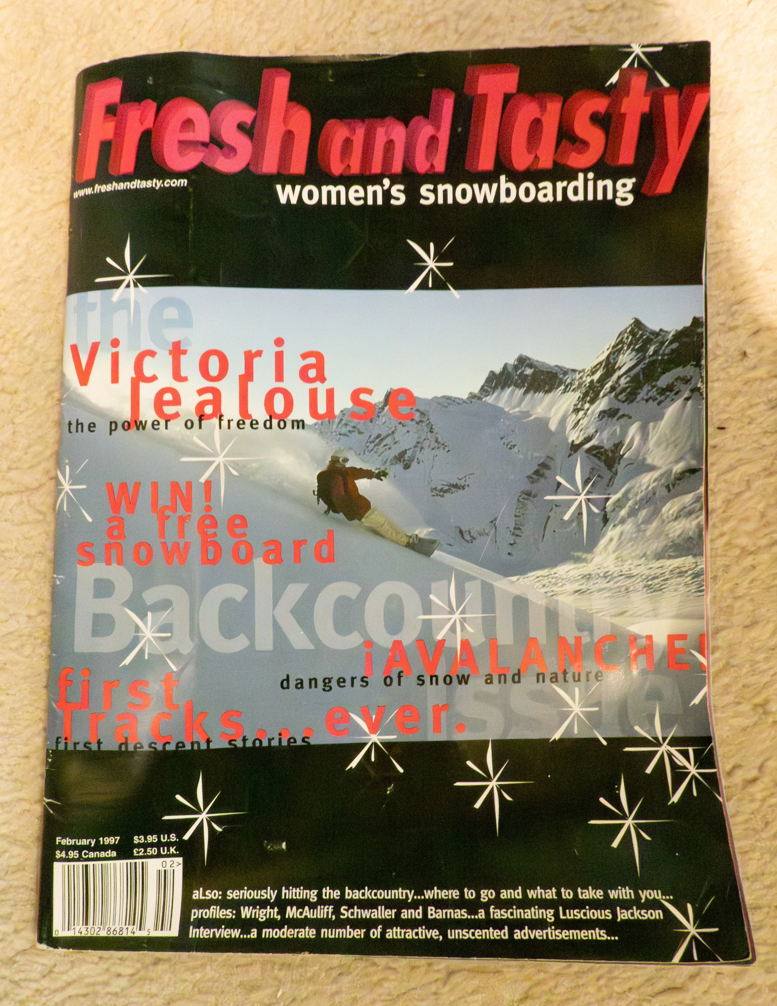
A page from the past — The author’s maiden snowboard touring trip to this classic Continental Divide destination was documented in Fresh and Tasty, a woman’s snowboarding magazine, launched out of Massachusetts in 1995. Mt. Joffre is located between B.C.’s Height of the Rockies Provincial Park and Alberta’s Peter Lougheed Provincial Park.
I was sitting on a cushy pad of Rocky Mountain heather, admiring the view and the sunset while I devoured the last of my backcountry burrito. My shoulders and feet ached from carrying my pack and snowboard up seven miles: 1,902 vertical feet of hiking, bushwacking, and scrambling on exposed scree slopes … and we were only halfway there.”
This is the opening paragraph of my second-ever published magazine article, describing our snowboard descent of the 3,449-metre Mount Joffre, one of the Canadian Rockies’ 11,000ers — or peaks over 11,000 feet. I accomplished the objective with three friends in August 1996, the article retelling it ran in a U.S. women’s snowboard magazine called — no jokes — Fresh and Tasty.
Mangin Glacier had long been a ski objective, but we felt a bit like pioneers, lugging our snowboards all the way there. After snowboarding through most of the 1990s, I’ve switched permanently to alpine touring skis: my first love is backcountry exploring, and although splitboard technology has much improved over the years, for me, skis are the best tool for the job.
Reading my story in Fresh and Tasty now gives me lots to think about. It was my biggest adventure to date, and my first time wearing crampons. I also would never have imagined that some 25 years later, I would write a book called Stories of Ice, all about our glaciers in Alberta and B.C., and the many things we do on them — pursue adventures, conduct scientific research, and create art.
At that time, snowboarding any glacier in Western Canada’s mountains in August was possible. Glaciers were there, melting slowly, as they had for the previous 100 years. In heavy snow winters, they grew.
Not so today. Twenty years ago, when I first began interviewing glaciologists and other climate scientists, they described how, as earth’s temperatures rose in response to our burning fossil fuels, Canadians could expect bigger and hotter wildfires, more drought, and greater temperature extremes. A paper published in 2015 by UBC’s Dr. Garry Clarke determined that the Rockies’ and other interior glaciers would lose 90 per cent of their ice by 2100.
Then the 2021 Heat Dome happened and the term “glacial pace” ceased to describe a slow-moving change. If you have a favourite glacier, no doubt you can see the melting before your eyes.
I was pleased to hear some adventurers skied Mangin Glacier on Mount Joffre this spring. No one, however, has been able to ski from Joffre’s summit in August in many years. With this knowledge, I have a deeper appreciation for our experience, understanding that sun-cupped ski slopes don’t exist there in summer anymore. And, regardless of the time of year, I’ve still never met another woman who snowboarded Mount Joffre.
~ Written by Lynn Martel
Find this full-length story and more in The Trench’s Winter 2025/26 edition: